In 2016, 16-year-old Mekayla Bali spent hours making untraceable calls at Tim Hortons, then vanished. Despite footage of her on the phone all morning, records showed zero calls that day. Her Instagram bio read only ‘goodbye,’ and three months later, her Snapchat messages were opened by someone — nobody knows who.
Events Before April 12
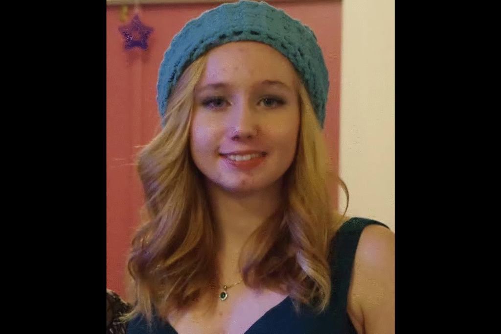
Mekayla attended Sacred Heart High School, a religious school in Yorkton, where her closest friends included Shelby and Oksana. A third friend, Amy, was also fairly close to her. Mekayla used several social media and messaging applications, including Snapchat, Facebook and Instagram.
She was also believed to have used Kik, an application on which strangers can contact one another without accepting a friend request and on which users appear only by a screen name. She regularly communicated with people she had met through these platforms.
Her friends knew of at least four young men with whom she had been in contact. Some lived elsewhere in Canada, and at least one lived in the United States. Much of what she discussed with such contacts was unknown even to her closest friends.
On Valentine’s Day that year, about two months before April 12, a bouquet of roses was delivered to her during drama class, arriving in an unmarked cardboard box. People around her found the delivery strange. Mekayla would not tell anyone who had sent it, even when she was asked directly.
To her friends, April 11 seemed an ordinary school day. Mekayla left school at lunchtime with Shelby and Oksana, and the three drove to a fast-food restaurant, where they talked about the ordinary concerns of teenagers.
During the conversation, Mekayla said she wanted to go somewhere, naming Moose Jaw or Prince Albert as possible destinations. She did not make clear whether she would travel alone or with other people.
Her friends took the remark as a wish to move away after graduation. Mekayla often spoke of moving to, or visiting, other places, and the girls regularly discussed leaving their small town, which lacked the fashionable stores they wanted and which they found too limiting.
After lunch, she returned to her Christian ethics class, where her teacher noticed that she seemed upset.
Other classmates recalled Mekayla saying that day that she was going to Regina on a family vacation. Regina is about two hours from Yorkton. One friend also thought she heard Mekayla mention a possible family trip to Saskatoon.
Shelby had also overheard Mekayla mention a young man named Josh and asked her about him, but Mekayla did not respond. Shelby did not know who Josh was, and he was not a student at their school.
Amy was told by Mekayla that a man named Christopher was coming to Saskatchewan to meet her. Mekayla offered no further details about either man.
School ended at about 3:40 p.m. At 4:35 p.m., Mekayla sent Oksana a text message asking whether she could take her to the TD Bank the next day. She described the errand as extremely important and said she needed Oksana’s help. Oksana agreed.
Mekayla then called the bank’s customer service line three times and transferred $25. It is not clear whether the money went to another person’s account or between accounts of her own.
Between about 8:50 and 9:30 that evening, she sent text messages to three people. She told Amy that she needed help but did not respond when Amy asked what kind.
She wrote to Shelby about a boy, saying that she felt bad for someone and that she was crying and very upset. She told an ex-boyfriend that she was unhappy and was thinking of going to Regina for a couple of days.
She was excited about her music class, where a large recital was approaching, and she spent the night practicing for it.
The Morning of April 12
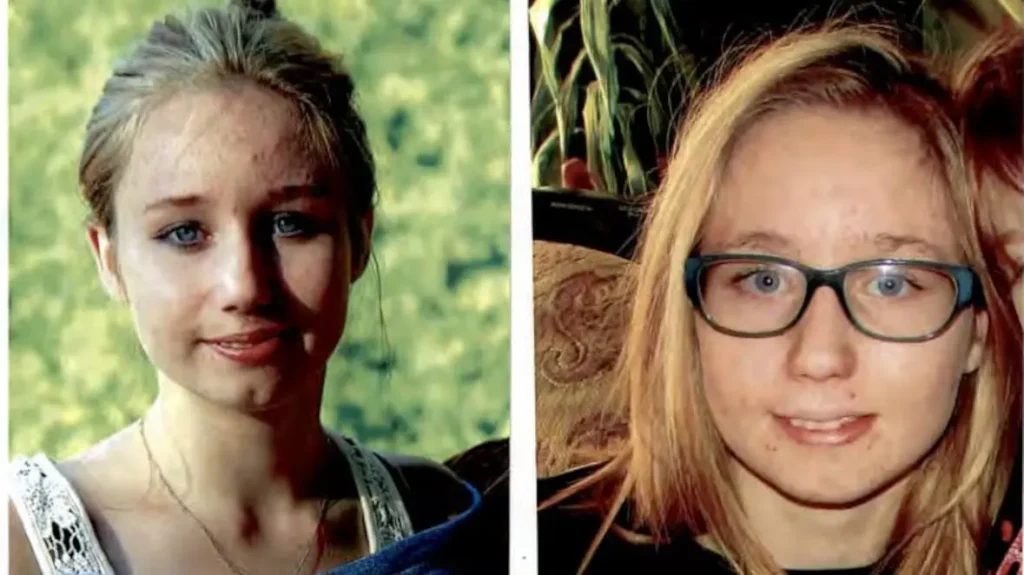
Mekayla lived in Yorkton with her mother, her younger brother and her younger sister. On school days, she and her mother usually woke at the same time and prepared for the day together, talking about their plans and the things going on in their lives, listening to music and joking around. April 12 followed this pattern, and her mother noticed no change in her behavior.
At 6:41 a.m., Mekayla sent Oksana another message about the trip to the bank. Oksana replied that the bank probably would not open until 8:00 a.m.
Mekayla answered by asking how Oksana planned to take her in that case. Oksana was unable to do so, because the bank opened only around the time school began.
Mekayla’s grandmother regularly drove her to school and to her music class, and she also drove Mekayla’s mother to work. That morning, she dropped Mekayla’s mother off first and then took Mekayla to school, arriving between 8:10 and 8:20 a.m.
At 8:21, only minutes after her arrival, security footage captured Mekayla inside the building, placing a binder in her locker. By 8:26, she had left through a back entrance. Her ex-boyfriend sent her a message asking where she was. It is not known whether she replied.
At 8:51 a.m., roughly half an hour after she had been seen at the school, Mekayla reached the bank she had asked Oksana to take her to. It had not yet opened, and she waited outside, talking on her phone.
Once the doors opened, she went inside and withdrew $55 from an account. She left the bank by 8:55 and stood outside for a time, again on her phone.
She then headed to Terry’s Pawn and Bargain, where she arrived at about 9:00 a.m. as the owner was doing his morning chores.
She tried to pawn one or two small silver rings, though the owner could not recall exactly how many. The rings had little value, and he did not make an offer. Mekayla did not appear distressed. She thanked him and left.
Late Morning

Mekayla’s next stop was a local Tim Hortons, where she was seen at about 9:10 a.m. She bought a coffee and sat down with her phone. Separate footage showed what appeared to be her taking the phone apart and putting it back together.
She was carrying a full backpack. Her friends considered this out of character, and it led them to worry that she had packed it for a trip. She usually brought only a purse to school, kept her belongings in her locker, and took home only what she needed.
Thirteen minutes after arriving, at 9:23, she walked to the exit, turned around and came back inside, then left through a different door. She did not appear on camera again until about 9:40, when she walked out from behind a Giant Tiger store. She returned to Tim Hortons at 9:49, apparently talking on her phone as she entered.
At about 10:12, roughly twenty minutes after her return, Mekayla sent Shelby a message reading, “Hey, I need help.” Over the next half hour, she used her phone for six separate calls, with breaks between them.
She then wrote to Shelby again: “Nevermind I figured it out.” Immediately afterward, she picked up her bags and left the restaurant, only to turn around and walk back in. She made another series of calls, and she remained on and off her phone throughout.
At 10:39, during one of the last of these calls, she began looking around the restaurant as though searching for someone. When the call ended at 10:43, she went directly to a woman seated at a nearby table and asked for help getting a hotel room.
The woman said she was unsure whether Mekayla needed money or simply someone old enough to book the room, and that Mekayla did not say where she wanted it. The woman declined. Mekayla showed no sign of being upset. She returned to her booth, began another call, and left Tim Hortons within a minute.
Her movements over the next hour are not known. She was next seen shortly before noon, back at the school, where she spoke with two students. She told them she was about to take a bus to Regina for a vacation.
The conversation lasted only minutes. One of them thought she might have had two phones. She also sent friends a message saying she would see them at lunch, but she did not remain at the school.
The Bus Station and the Afternoon
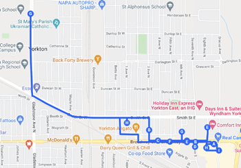
After leaving the school, Mekayla went to the local bus station. The employee selling tickets recalled her asking when the next bus to Regina would leave and being told it would depart at about 5:00 p.m. She did not buy a ticket.
Instead, she stopped at the small café inside the station and ordered poutine. She was seen leaving between 1:00 and 1:45 p.m. A customer reported that she left with a stocky man who had a tattoo of a cross with flames below his left elbow. There were no further sightings of her.
Her grandmother arrived at the school at around 3:40 p.m. to drive her to music class, but Mekayla was not waiting for her. This was highly unusual, as she consistently kept to her arrangements and told her family where she would be.
Her grandmother assumed she had stayed inside and went into the building to look for her. Teachers and students she spoke to had not seen Mekayla since early that morning, and she had not attended any of her classes.
The grandmother drove to Mekayla’s mother’s workplace to tell her that something was wrong. Her mother at first assumed there had been a misunderstanding and that Mekayla was in a classroom or had been kept at the school for some reason.
The two women returned to the school and searched it thoroughly. Mekayla’s mother grew desperate enough to look under the school buses and in other unlikely places.
They then went to the place where Mekayla took her music lessons, thinking she might have gone early and forgotten to tell her grandmother. She was not there. Texts and calls to her phone went unanswered.
Her mother then considered whether Mekayla had run away. As a single parent, she kept a stash of cash at home. Mekayla knew where it was and had permission to use it when she needed to.
Her mother expected that a girl planning to run away would take most or all of it. When she checked, none of it was missing. Mekayla’s room also appeared undisturbed.
She had left behind her phone charger, her makeup, which mattered to her because she was self-conscious about her acne, and her acne medication, a dose of which she never skipped. Nothing suggested she had left for an extended period.
Just before 8:00 p.m., nearly twelve hours after her grandmother had dropped her at school, Mekayla was reported missing to Yorkton RCMP.
The Investigation
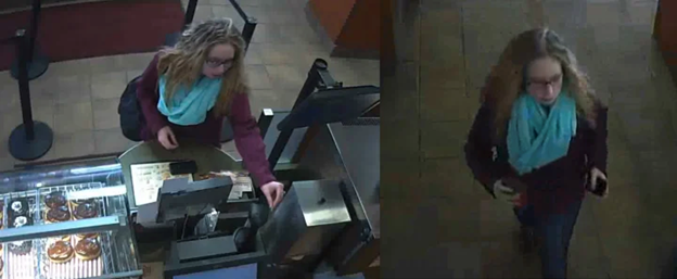
Yorkton RCMP began by interviewing Mekayla’s friends, and after three weeks the file passed to the General Investigations Section, whose officers spent hundreds of hours reviewing surveillance footage from local businesses.
Investigators did not learn that Mekayla had asked a woman at Tim Hortons for help with a hotel room until three months after her disappearance.
The tattoo described by the customer at the bus station became their first significant lead, and a sketch of the cross was released to the public. A man later came forward, and RCMP questioned him and concluded that he had simply held the door for Mekayla. His name was never released.
Mekayla’s phone was switched off at 6:51 a.m. on April 13, roughly eleven hours after she was reported missing. Authorities have said that someone shut it off, rather than the battery dying or the device powering down on its own.
Since that moment, there has been no activity on her phone, her social media accounts or her bank card. Investigators examined her phone records to learn whom she had been speaking to.
The records showed no calls made or received on April 12, even though footage showed her speaking on a phone repeatedly. It has not been established whether she used a second phone or a calling feature within a messaging application, and whom she was speaking with during those calls remains unknown.
Her social media accounts were considered crucial to the investigation, because they were the main way she communicated with other people. Gaining access to them took authorities ten months.
Many of the platforms are based in the United States, and privacy rules differ between that country and Canada. All of the accounts still exist but are inactive. Mekayla had several Instagram accounts.
One has hundreds of followers but no photographs, which suggests pictures may have been deleted. Her profile biography reads only “goodbye.” Much of the information was protected by privacy laws or had not been stored, so investigators gained little beyond what they already had.
About three months after Mekayla disappeared, messages that Shelby had sent her on Snapchat on the day she went missing were opened. Authorities have not been able to confirm who opened them.
RCMP contacted all of the hotels in Yorkton and connecting cities, but nobody remembered seeing Mekayla and she did not appear in any surveillance video. The canvass did not extend to Regina or Saskatoon.
In August 2017, the RCMP dive team searched Hopkins Lake, near her school, to cover off possibilities such as an accidental death, and found only golf balls and beer cans.
Investigators then turned to the people who might have been connected to her. They first considered whether Mekayla had set out to find her father. She had never known him or his name.
She had told some classmates that he was dead and others that she wanted to find him. A man named Rick Breit said he believes he is her father, although he cannot be sure.
RCMP telephoned him five days after she disappeared, and he said Mekayla never contacted him and that he did not think she knew his name.
Her mother has said there is no evidence that he is her father, and RCMP have said there is no evidence he was involved in her disappearance. He runs his own Facebook page for the case. Authorities also identified the sender of the Valentine’s Day flowers and said that person had nothing to do with what happened to her.
Authorities next tried to trace the two men Mekayla had mentioned to her friends on April 11. Christopher lived in North Carolina and had messaged her through Instagram. RCMP identified and interviewed him, as did police in the United States, and his house was searched.
A man who said he was that Christopher declined to answer a news outlet’s questions about his conversations with her, but wrote in an email that she had suffered with self-harm a few years earlier and that he had encouraged her to fight it and to look toward God.
An RCMP investigator said there is no evidence he was in Canada when Mekayla disappeared, and none that she was suicidal at that time.
Josh was harder to trace. Because police had no last name for him, they interviewed multiple people with that name, among them a man from Churchbridge who knew her from a youth event and said they had stopped talking at least three years before she disappeared. An RCMP investigator said nothing indicated that he was involved.
More than 1,000 tips have been received and investigated, yet RCMP are no closer to learning where Mekayla is or what happened after she left the bus station. Police found no evidence that she had a passport and have no reason to believe she left Canada.
A reported sighting in Washington State led to a missing person file there, and in 2022 Homeward Bound trucks bearing her photograph were unveiled in Blaine, Washington.
Police have said that tips pointing to drug involvement or human trafficking were followed up and produced nothing, though her mother has said she might have been a victim of human trafficking.
The family’s reward for her safe return, $25,000 in 2016, now stands at $100,000. RCMP want to hear from anyone else she may have approached for help that day and have said such people are not expected to be in any trouble.
Her family has put up more than 6,000 posters of her in Canada and the United States, and a candlelight vigil is held in Yorkton on each anniversary of her disappearance.
In April 2026, ahead of the tenth anniversary of her disappearance, the Saskatchewan RCMP said its Historical Case Unit continues to investigate and follow up on every tip. Insp.
Ashley St. Germaine said someone who did not want to speak at the time may be ready to do so now. The family said that for ten years their lives have been on hold.
Remembering Mekayla
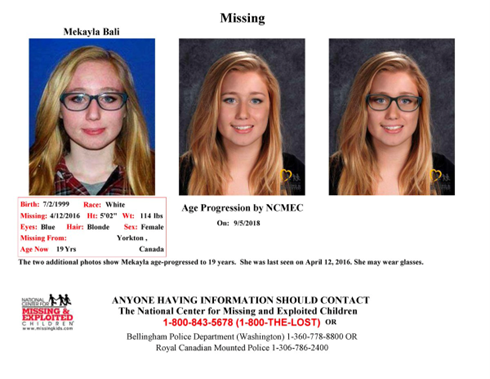
Mekayla Bali is remembered by those who knew her as a really sweet young girl. She was shy, but her shyness did not keep her from being popular and well liked. She endured bullying, and her acne sometimes caused her to withdraw into herself.
Even so, she genuinely loved and cared about the people around her and wanted everyone to feel welcome and content at all times. She was an attentive listener who would sit with anyone who needed to talk, and she offered advice whenever she could.
An overwhelming wish to look after others shaped her ambitions. She told friends she wanted to be a teacher or a veterinarian because she loved children and animals.
Mekayla was a daughter, a granddaughter, a niece, an older sister and a friend. She was also talented. She played the violin and took part in drama, and she was already regarded as very gifted.
Her wish to make others feel special was clear when she learned to play the accordion so that she could play “Happy Birthday” for her aunt on her birthday. Those who knew her described a young woman with many plans for her future, even if, like most teenagers, she sometimes found life complicated.
Her absence has reshaped her family’s daily life. Her aunt writes a letter or an email to her at least once every day and has done so since the day she went missing. Immediately afterward, her mother and siblings all slept together in the living room, because nothing at home felt right.
They still cannot sit at the dining table, since the empty place there does not feel right either. The family has said that normality and continuity have disappeared from a fractured household, and that no one can sleep comfortably while not knowing where the child is.
Her mother, afraid that something might happen to her other children, took them out of school for a time. When she sent them back, she visited them at school during her lunch break every day.
In April 2026, Paula Bali said that time has not made it easier and that she does not think she will ever stop looking for her daughter.
Mekayla is loved and missed by her family, her friends and the community of Yorkton, all of whom continue to hope that she will be found.
Scientists Use Thunderquakes to Map Hidden Rock Beneath Pennsylvania Without Drilling
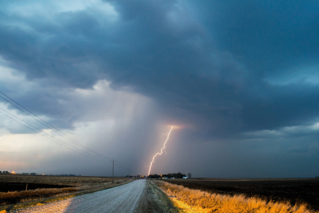
Scientists have found a new use for thunder that has nothing to do with its rumble in the sky. Researchers at Penn State used 458 thunder-generated seismic events to create a geological image of the rock beneath a Pennsylvania campus without drilling any new holes.
Their findings, published in the journal Science Advances, show that an overhead storm can act as a useful tool for identifying subsurface geology.
How Thunder Can Be Used to Probe the Deep
Geophysicists have traditionally relied on strong outside forces to investigate geology hidden beneath the surface. An earthquake is one example, as are vibrations from large vehicles or from controlled active sources placed at the surface.
What the field had not been able to use effectively in the past is the vibrations caused by thunder, since a distant lightning strike sets off a complicated series of mixed shock waves that rarely travel the same path.
The issue is one of physics. The channel of ionized air created by a strike takes the form of a non-uniform line, causing numerous pockets of energy to form as a single flash dies down.
Each of these pockets takes the form of a shock wave that dissipates into the air as sound, with the collective noise being recognizable as thunder.
When lightning bolts discharge, the tortuosity and nonuniform plasma temperatures along the superheated channel generate multiple semi-discrete shock bubbles along the bolt akin to a string of pearls.
As one of these waves touches down on the surface, part of it couples into the ground and produces a seismic wave. The speed of these waves is partially determined by the properties of the earth, with different wave speeds providing information about subsurface materials.
A careful analysis of waves at a given point reveals important information about the layer of earth at that depth, with longer wavelengths providing information about deeper geology.
Subsurface layering creates a uniquely dispersive wavefield, providing a physical basis for thunder as a source for seismic tomography.
The challenge with using thunder for imaging lies in the fact that the energy it produces is scattered in all directions, interrupted by buildings, hills, and variations in bedrock.
This challenge was overcome by the researchers, who used distributed acoustic sensing and advanced processing to isolate useful signals from this complexity. The result was a new way to identify underground formations with useful resolution.
Real-world infrastructure, topography, and bedrock heterogeneity can severely complicate analysis of thunderquakes, which has caused them to go largely untapped as practical sources.
How a Simple Phone Line Became a Sensor
The team at Penn State made their discovery with the help of existing telecommunications lines. An approximately 2.5-mile, 4-kilometer cable, buried just a few feet underground beneath the University Park campus, served as the foundation for the research led by Professor Tieyuan Zhu, an associate professor of geosciences at Penn State.
The researchers developed a new way to use distributed acoustic sensing technology, or DAS, to better understand how atmospheric acoustic waves transfer energy into the ground.
Zhu and his team used fiber-optic strain sensing to read the vibrations that made their way along the length of the cable.
The array, part of the FORESEE network, which stands for Fiber-Optic foR Environmental SEnsEing, recorded continuous seismic data across 2,137 channels at 2-meter channel spacing from 2019 to 2021, with a 10-meter gauge length and sampling at 250 or 500 Hz.
Using a laser beam shot down the fiber, the team recorded how the phase of backscattered light shifts due to tiny strains caused by seismic waves moving through the ground.
Nolan Roth, a doctoral candidate at Penn State who has since moved to Ohio State University as a postdoctoral researcher, manually reviewed more than 2 years of data.
Roth and his colleagues were able to identify 458 high-quality thunderquake events and match their timing to reports made by the National Lightning Detection Network, which provided information on the location and peak current of the lightning strikes.
“With DAS, we are recording hundreds of samples every second and every few meters along the cable,” Roth said while describing the thoroughness of the work. This allowed the team to examine the data set for patterns that could be used to identify geological features previously unseen.
What the Underground Map Revealed About the Campus
A single thunderquake did not have enough resolution for the researchers to work with, so the team stacked together multiple readings using cross-correlation virtual-source interferometry.
Using the 2,137 sensor segments, they created an averaged model of the vibrations where randomness canceled out, leaving behind patterns caused by repeated readings.
The processing generated about 141,000 virtual-source combinations from the 458 thunderquakes, which were ultimately reduced to 309 virtual shot gathers for inversion.
Taken together, these results formed a cross-section of the campus that reached approximately 100 meters, about 330 feet, underground. Embedded within this profile were four unusual zones where the speed of the vibration was slower than surrounding areas.
The most notable features are four low-velocity weak zones, WZ-1 to WZ-4 which are interpreted as areas containing weaker materials such as sediments, weathered rock, fractures or fluids.
The four pockets had average widths of about 40 to 100 meters, and depths of about 28 to 50 meters, in the Nittany Dolomite and Stonehenge Limestone underlying the campus.
The researchers interpreted the dimensions and locations of the weak zones as consistent with fracture complexes, which are concentrated zones of fracturing that can provide pathways for groundwater and contribute to weathering of surrounding rock.
The research team cross-referenced their findings with older drill samples taken from the campus, as well as two sets of engineering surveys. The results were broadly consistent with known rock layers and nearby geophysical measurements.
Independent engineering Multichannel Analysis of Surface Wave surveys and stratigraphy from the deepest available borehole log were broadly consistent with nearby models.
Additional readings by satellite using time-lapse Interferometric Synthetic Aperture Radar observations from 2017 to 2025 revealed that areas around WZ-1 and WZ-2 showed ongoing line-of-sight subsidence, further supporting the findings.
One of the zones sits about 0.6 kilometers southeast of the university’s football stadium, near an area where voids in the rock had previously been documented, while another is about 1.6 kilometers from the Mount Nittany Medical Center where subsurface voids were known.
The other two pockets showed no signs of active subsidence which may reflect increased ground stability due to urban development, a lesser degree of fracturing or masking of the signal by infrastructure.
The limits of the research were defined by the tools used, as extremely shallow sediments with shear-wave phase velocities less than the air-wave velocity cannot be resolved, and simulations were limited to a dominant frequency of about 4 Hz without introducing significant numerical dispersion.
Why This Discovery Goes Far Beyond One College
Limestone is a sedimentary rock found across the central United States, with the ability to dissolve underground, forming unique landforms known as karst. Karst terrains exist across much of the Central and Eastern United States and about 20 percent of U.S. land surface is classified as karst.
Karst is important because it contains highly productive but vulnerable groundwater systems and is characterized by features such as caves, springs, sinkholes, fractures, and underground conduits.
Thunderstorms provide a valuable alternative to investigating local geology. The central and eastern United States experience frequent thunderstorms and comparatively few earthquakes in many areas, making passive seismic surveys based on earthquakes more difficult.
The Penn State researchers therefore see thunderquakes as a potential source of seismic energy in regions where traditional seismic sources are limited.
“What we’ve done,” said Zhu, “is demonstrate that we can actually use those lightning signals to study the geology beneath the surface. In fact, the same principle can be used to great effect in a number of situations.”
Geologists are already considering future applications, since seismic imaging can be used to evaluate geohazards such as sinkholes and landslides, assess groundwater and mining resources, and study volcanoes and magma pockets.
The passive nature of the study also means it could potentially be used in places far removed from development, including the Arctic and densely populated urban centers where large-scale excavation is difficult.
What has yet to be seen is whether the four weak zones found beneath the Penn State campus could be used as an early indicator for potential sinkholes in the region.
The four areas were not directly drilled into as part of this study, and the researchers did not establish that they are future sinkhole sites.
Roth and his colleagues have suggested that further research could allow the findings to go beyond one campus, with additional applications in the field of geoscience still being explored.
Zhu has also noted that the findings could serve a purpose beyond simply studying the Earth. The results could prove useful for scientists looking at tectonic movements on other planets, since quakes on other worlds are not well understood, so having a different source for seismic imaging might be necessary.
Lightning and thunder are not unique to Earth, and thunder-induced seismicity could potentially provide alternative sources for subsurface exploration on other worlds, although this remains a future possibility rather than a demonstrated application.
Following the scans, Zhu described the process as a means of allowing people to see underground with the help of a storm in the sky.
Sources
Thunderquakes: A new way to image the Earth’s subsurface — Penn State University
Roth, N. et al., Science Advances (DOI: 10.1126/sciadv.aeg8096)
Thunderstorms offer scientists a new way to see underground — Earth.com
Thunderquakes Could Help Scientists See Beneath Earth’s Surface — Discover Magazine
Scientists Planted Telecom Cables to Find ‘Thunderquakes.’ Here’s What Happened — Gizmodo
Scientists use thunderquakes to X-ray Earth beneath cities — The Weather Network